
Professional Drone Photography & Video Services for Construction
Accurate Aerial Imagery to Power Every Phase of Your Build
At Drone Discovery Ltd, we specialise in high-quality drone photography and videography for construction sites—capturing your project from planning through to final completion. Our drone footage provides a clear, professional perspective that supports progress tracking, documentation, and stakeholder engagement.
Whether you’re working on a residential development, commercial build, or large-scale infrastructure project, our construction drone services deliver the visuals and data you need—efficiently, safely, and affordably.
Why Use Drones on Construction Sites?
Unmanned aerial vehicle (UAV) services are transforming the way construction companies operate. From capturing impressive site overviews to detailed surveys, aerial photography and drone videos offer an efficient and cost-effective way to document and manage a build.


Key Benefits of Construction Drone Photography and Video
High-resolution aerial photography of all stages of construction
2D/3D mapping and orthomosaic outputs for accurate site analysis
Automated missions can be saved and repeated, ensuring the same viewpoint and flight path are captured each time for consistent comparisons over time.
Visual content for client updates, marketing, and investor reports
Safer inspections of roofs, bridges, and elevated structures
Monthly or milestone-based progress tracking
Support for planning applications, quantity surveying, and CAD integration
Fully Certified and Safety-First Drone Operations

Our drone pilots are fully certified by the Civil Aviation Authority (CAA) and experienced in operating safely within active construction environments. Every flight is backed by comprehensive risk assessments and safety protocols, ensuring compliance with UK regulations.
We work directly with site managers, project coordinators, and health & safety teams to ensure minimal disruption and maximum output.
High-Resolution Mapping & Survey Solutions
Using Real Time Kinematic (RTK)-enabled quadcopter drones, we offer a range of services for the construction industry:
Detailed aerial photos and 4k drone footage
Orthomosaic maps for planning and documentation
Photogrammetry for precise structural analysis
3D models for BIM, GIS and CAD platforms
Built for the Construction Industry

We’ve worked with construction organisations, contractors, architects, developers, and surveyors across the UK, helping them gain visual insights that support project success. Our footage is often used for:
Construction progress monitoring including material volume calculation
Insurance and damage assessment
Contract retention documentation
Health & safety monitoring
Client and investor presentations
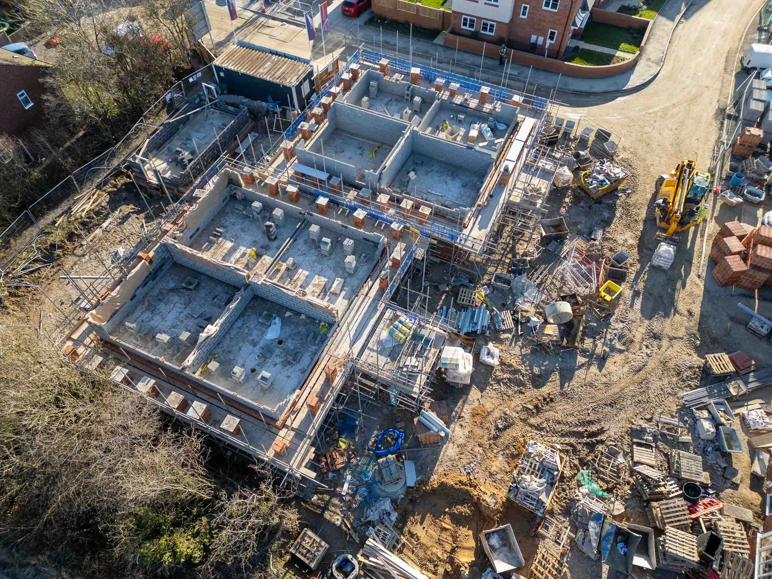
Construction Monitoring Drone Photography
Click on the image to enlarge and see the detail captured by drone photography.
A top-down drone image of a housing development site is a great way to show progress
Drone photos are a perfect way to show land boundaries for site developments
Drone inspections completed in a fraction of the time for hard to reach places like bridge supports
Drone inspections easily capture tricky locations like under bridges
Drone shots captured from the same position each time give a consistent update on site progress
An orthomosaic image comprised of multiple drone shots shows the full site in one image
Let’s Elevate Your Next Build
If you’re looking to improve the way you document, monitor, or promote your construction project, our professional drone photography and video services are here to help.
Call us on 07967 962 627 for a FREE, no-obligation quote. You can find a selection of our construction monitoring drone photography & videography on our portfolio page.